Pacific Ocean
Meteorologists have been talking for weeks about a snowy season ahead in the southern Rockies and the Sierra Nevada. They anticipate more storms in the U.S. South and Northeast, and warmer, drier conditions across the already dry Pacific Northwest and the upper Midwest. One phrase comes up repeatedly with these projections: a strong El Niño is coming. It sounds ominous. But what does that actually mean? We asked Aaron Levine, an atmospheric scientist at the University of Washington whose research focuses on El Niño. NOAA explains in animations how El Niño forms. What is a strong El Niño? During a normal year, the warmest sea surface temperatures are in the western Pacific and the Indian Ocean, in what’s known as the Indo-Western Pacific warm pool. But every few years, the trade winds that blow from east to west weaken, allowing that warm water to slosh eastward and pile up along the equator. The warm water causes...
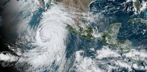
Tropical Storm Hilary made landfall on Mexico’s Baja peninsula, and its damaging wind and heavy rainfall moved into Southern California on Aug. 20, 2023. For the first time ever, the National Hurricane Center had issued a tropical storm watch for large parts of Southern California. Forecasters warned of a “potentially historic amount of rainfall,” and the governors of California and Nevada declared states of emergency. Hurricane scientist Nick Grondin explained ahead of landfall why the storm, with help from El Niño and a heat dome over much of the country, could bring flash flooding, wind damage and mudslides to the region. How rare are tropical storms in the Southwest? California had only one confirmed tropical storm landfall in the past. It was in September 1939 and called the Long Beach Tropical Storm. It caused about US$2 million dollars in damage in the Los Angeles area – that would be about $44 million today. A hurricane in 1858 came close bu...
El Niño is officially here, and while it’s still weak right now, federal forecasters expect this global disrupter of worldwide weather patterns to gradually strengthen. That may sound ominous, but El Niño – Spanish for “the little boy” – is not malevolent, or even automatically bad. Here’s what forecasters expect, and what it means for the U.S. What is El Niño? El Niño is a climate pattern that starts with warm water building up in the tropical Pacific west of South America. This happens every three to seven years or so. It might last a few months or a couple of years. Normally, the trade winds push warm water away from the coast there, allowing cooler water to surface. But when the trade winds weaken, water near the equator can heat up, and that can have all kinds of effects through what are known as teleconnections. The ocean is so vast – covering approximately one-third of the planet, or about 15 times the size...
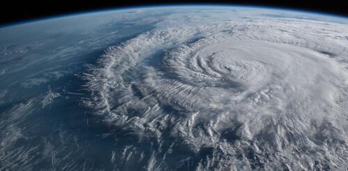
The Atlantic hurricane season starts on June 1, and forecasters are keeping a close eye on rising ocean temperatures, and not just in the Atlantic. Globally, warm sea surface temperatures that can fuel hurricanes have been off the charts in the spring of 2023, but what really matters for Atlantic hurricanes are the ocean temperatures in two locations: the North Atlantic basin, where hurricanes are born and intensify, and the eastern-central tropical Pacific Ocean, where El Niño forms. This year, the two are in conflict – and likely to exert counteracting influences on the crucial conditions that can make or break an Atlantic hurricane season. The result could be good news for the Caribbean and Atlantic coasts: a near-average hurricane season. But forecasters are warning that that hurricane forecast hinges on El Niño panning out. Ingredients of a hurricane In general, hurricanes are more likely to form and intensify when a tropical low-pressure system encounter...
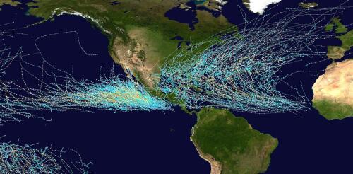
The official 2023 hurricane season forecasts were just released, and while the Atlantic may see an average storm season this year, a busier-than-normal season is forecast in the eastern Pacific, meaning heightened risks for Mexico and Hawaii. A big reason is El Niño. El Niño typically means trouble for the Pacific and a break for the Atlantic coast and Caribbean. But while this climate phenomenon is highly likely to form this year, it isn’t a certainty before hurricane season ramps up this summer, and that makes it harder to know what might happen. It’s also important to remember that even in quiet years, a single storm can cause enormous destruction. As climate scientists, we study how climate patterns related to the frequency and intensity of hurricanes – information that is used to develop seasonal forecasts. Here is a quick look at how El Niño affects storms and why it tends to cause opposite effects in two basins separated only by a...


