Hurricane Ian
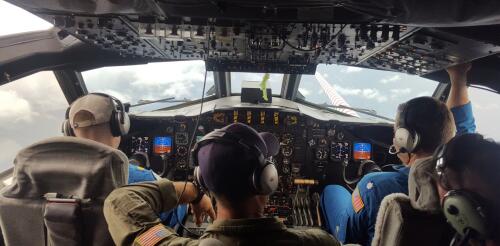
As a hurricane intensifies, hurricane hunters are in the sky doing something almost unimaginable: flying through the center of the storm. With each pass, the scientists aboard these planes take measurements that satellites can’t and send them to forecasters at the National Hurricane Center. Jason Dunion, a University of Miami meteorologist, has led hurricane field programs for the National Oceanic and Atmospheric Administration. He described the technology the team uses to gauge hurricane behavior in real time and the experience aboard a P-3 Orion as it plunges through the eyewall of a hurricane. What happens aboard a hurricane hunter when you fly into a storm? Basically, we’re take a flying laboratory into the heart of the hurricane, all the way up to Category 5s. While we’re flying, we’re crunching data and sending it to forecasters and climate modelers. In the P-3s, we routinely cut through the middle of the storm, right into the eye. Picture an X p...
Hurricane Ian strengthened into a major hurricane on Tuesday as it headed for Florida and was on track to bring dangerous storm surge to the coast and flooding rainfall to large parts of the state. Several areas were under evacuation orders. After a slow start to the 2022 Atlantic hurricane season, Ian formed in ideal conditions, with minimal vertical wind shear, which can tear apart a storm, and warm ocean surface waters providing fuel. Forecasters expect Ian to remain a major hurricane – meaning Category 3 or higher on the Saffir-Simpson Hurricane Wind Scale, with winds over 110 mph – as it heads for landfall in Florida, expected Wednesday. But the scale doesn’t take water risk into account, and flooding and storm surge are both major risks from Ian. Large parts of the state could see 15 inches or more of rain from Hurricane Ian. National Hurricane Center As a meteorologist livin...

