Tropical storms
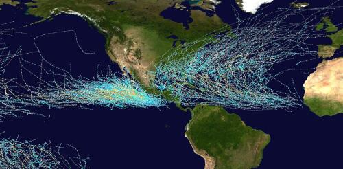
The official 2023 hurricane season forecasts were just released, and while the Atlantic may see an average storm season this year, a busier-than-normal season is forecast in the eastern Pacific, meaning heightened risks for Mexico and Hawaii. A big reason is El Niño. El Niño typically means trouble for the Pacific and a break for the Atlantic coast and Caribbean. But while this climate phenomenon is highly likely to form this year, it isn’t a certainty before hurricane season ramps up this summer, and that makes it harder to know what might happen. It’s also important to remember that even in quiet years, a single storm can cause enormous destruction. As climate scientists, we study how climate patterns related to the frequency and intensity of hurricanes – information that is used to develop seasonal forecasts. Here is a quick look at how El Niño affects storms and why it tends to cause opposite effects in two basins separated only by a...
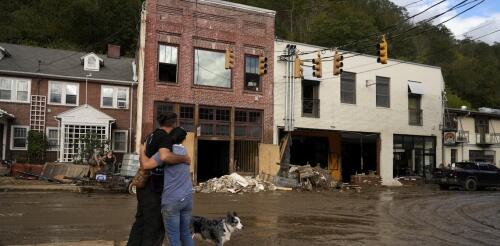
Some hurricanes are remembered for their wind damage or rainfall. Others for their coastal flooding. Hurricane Helene was a stew of all of that and more. Its near-record-breaking size, storm surge, winds and rainfall together turned Helene into an almost unimaginable disaster that stretched more than 500 miles inland from the Florida coast. At least 230 people died across Florida, Georgia, South Carolina, North Carolina, Tennessee and Virginia as Helene flooded towns, destroyed roads and bridges and swept away homes. In Florida, Helene’s storm surge caused damage along hundreds of miles of coast. As residents there cleaned up debris, another dangerous hurricane was headed their way. Some of the same areas hit hard by Helene on Sept. 26, 2024 – including Tampa Bay and Cedar Key – were forecast to see more flooding and an even higher storm surge in Tampa Bay from Hurricane Milton, expected to make landfall as early as Oct. 9. The majority of Helene’s vic...
Tropical cyclones have been growing stronger worldwide over the past 30 years, and not just the big ones that you hear about. Our new research finds that weak tropical cyclones have gotten at least 15% more intense in ocean basins where they occur around the world. That means storms that might have caused minimal damage a few decades ago are growing more dangerous as the planet warms. Warmer oceans provide more energy for storms to intensify, and theory and climate models point to powerful storms growing stronger, but intensity isn’t easy to document. We found a way to measure intensity by using the ocean currents beneath the storms – with the help of thousands of floating beachball-sized labs called drifters that beam back measurements from around the world. Why it’s been tough to measure intensity Tropical cyclones are large storms with rotating winds and clouds that form over warm ocean water. They are known as tropical storms or hurricanes in the Atlantic...
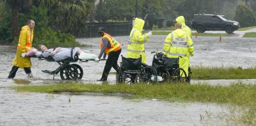
Hurricane Ian, one of the most powerful storms to hit the U.S., tore part of the roof off a hospital in Port Charlotte, Florida, and flooded the building’s lower level emergency room, sending staff scrambling to move patients as water poured in. At least nine hospitals and dozens of nursing homes had to transfer patients after losing access to clean water because of the storm. Health care services are essential at any time, but when disasters strike, those services become even more crucial as injuries rise. Yet in many coastal communities, the hospitals were built in locations that are at increasingly high risk of flooding during hurricanes. I study ways to improve disaster communications, including how health care organizations prepare for severe weather events. Here’s what research shows about the rising risks. High percentage of coastal hospitals at risk Given the impact of climate change, many areas are susceptible to severe weather events and hazards. Healt...
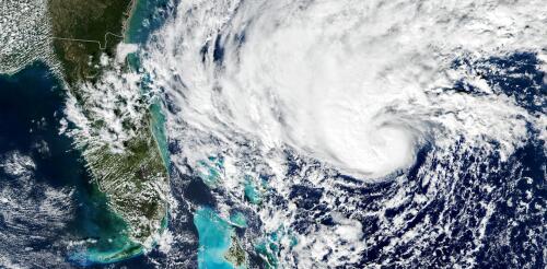
Hurricane Ian strengthened into a major hurricane on Tuesday as it headed for Florida and was on track to bring dangerous storm surge to the coast and flooding rainfall to large parts of the state. Several areas were under evacuation orders. After a slow start to the 2022 Atlantic hurricane season, Ian formed in ideal conditions, with minimal vertical wind shear, which can tear apart a storm, and warm ocean surface waters providing fuel. Forecasters expect Ian to remain a major hurricane – meaning Category 3 or higher on the Saffir-Simpson Hurricane Wind Scale, with winds over 110 mph – as it heads for landfall in Florida, expected Wednesday. But the scale doesn’t take water risk into account, and flooding and storm surge are both major risks from Ian. Large parts of the state could see 15 inches or more of rain from Hurricane Ian. National Hurricane Center As a meteorologist livin...


