
 italiano
 english
 français
 española
 中国
中国 日本の
日本の العربية
 Deutsch
 한국어
한국어 Português
 Russian

https://www.valigiablu.it/crisi-climatica-uragani-ondate-di-calore/
- |
The weekly round-up on the climate crisis and data on carbon dioxide levels in the atmosphere.
For the first time in the Atlantic Ocean a category 5 hurricane formed at the beginning of the summer and this is not a good sign for the rest of the year and our immediate future.This is the case of Beryl, the first major hurricane of a season that will arrive until late November, which went from tropical depression to storm and then to hurricane in the space of 48 hours.The speed with which Beryl transformed into a Category 5 hurricane is a bad sign for the Atlantic hurricane season which, fueled by increasingly rising ocean temperatures, is becoming more dangerous and unpredictable.So much so that, how underlines Simone Fant on Renewable Matter, some scientists are proposing to add an additional category – category 6 – to measure the intensity of hurricanes.

“This early-season storm activity is breaking records set in 1933 and 2005, two of the most intense Atlantic seasons on record,” said Philip Klotzbach, a seasonal hurricane forecaster at Colorado State University.
On June 28, Beryl was a tropical depression, with winds of 56 km/h.On June 29, it became the first hurricane of the season, a Category 1.On the morning of July 30, it rose to category 4, reaching winds of 250 km/h.When on July 1 it hit two islands in the archipelagos of Grenada and St.Vincent & the Grenadines, destroying 90% of homes and killing 11 people, had become a Category 5 hurricane.Then, weakened by the journey, he arrived in Houston, Texas, the fourth most populous metropolitan area in the United States, leaving 22 victims, millions of people without electricity and thousands of liters of sewage water dispersed into the environment.Then becoming a tropical depression, Beryl hit parts of Arkansas and Louisiana.
The higher temperatures in the Atlantic Ocean are contributing to the triggering of phenomena like Beryl, "where more than 29°C are currently recorded", he explains to Renewable Matter, Enrico Scoccimarro, scientist at the Euro-Mediterranean Center on Climate Change (CMCC).Hurricanes suck up warm ocean water and use it as fuel.In an optimal weather environment like that of late June, ample heat energy rapidly increases the intensity of the storm.“We see a trend towards the extension of the warm period in the Atlantic Ocean and therefore the intensification of storms becomes more likely in these months,” adds Scoccimarro.
Already in May, the National Oceanic and Atmospheric Administration (NOAA), had predicted in the Atlantic basin hurricane activity 85% “above normal”:in total between 17 and 25 storms, of which between 8 and 13 could become hurricanes.Another study Published on Scientific Reports had found that Atlantic hurricanes from 2001 to 2020 were twice as likely to develop from a weaker storm to a Category 3 or higher hurricane within 24 hours than from 1971 to 1990.The study adds to a growing body of evidence showing that rapidly developing major hurricanes are becoming more likely.
Experts agree on the role of anthropogenic global warming in the increase in temperatures in the North Atlantic even if it does not fully explain Beryl's exceptional nature.
“Obviously climate change affects everything, and it certainly has a hand in it.But it doesn't fully explain the sharp jump we saw in the spring of 2023 and which isn't over yet.There are other things at stake." explains to Guardian Brian McNoldy, climate scientist at the University of Miami.“Last year we had these record-breaking warm ocean temperatures in the Atlantic, but we also started to have a stronger El Niño later in the year, and all things being equal the El Niño action should have reduced the activity of hurricanes in the Atlantic.It probably did to some extent, but thanks to the ocean temperatures being so warm, in the end the hurricane season was still above average.”
It may also have played a role the reduction of aerosol pollution which, by reducing the amount of solar radiation that reaches the lower layers of the atmosphere, slightly cools the planet.
So what to do?In addition to the causes and the definition of new categories, scientists they are scrambling to predict better when And Why hurricanes like Beryl intensify rapidly and solutions must be found to better alert and prepare the population for potential disasters.
Storms that are more likely and quicker to turn into hurricanes mean greater dangers and, above all, less time for people to prepare.Last October, Hurricane Otis went up multiple categories in a single day before making landfall in Acapulco, Mexico, as a Category 5 hurricane resulting in the deaths of at least 52 people.
Predicting rapid intensification of a hurricane is tricky, however, explains Brian Tang, professor of atmospheric sciences at the University at Albany:“The models need to incorporate the environment around the storm and within it.The anatomy of a hurricane is more layered than it might seem from the ground:the relatively calm eye of the storm is surrounded by a region of violent winds, thunderstorms and heavy rain known as eyewall.From the center, 'rain bands' curves of clouds and thunderstorms spread out with various levels of intensity.In addition to trying to predict the location and strength of these parts of the hurricane, the models also need to represent the physics of how the atmosphere interacts with the ocean.”
In this week's climate round-up:
Global temperatures have averaged above 1.5°C for 12 months running
On the same days that Beryl hit the Caribbean and Texas, more than 70 million Americans were on alert for a heat wave that caused several deaths.On July 7, the thermometer registered 53.3°C in Death Valley National Park, California, an unprecedented value for this time of year.Record temperatures also in Las Vegas, Nevada, where 48.3°C were reached.Among the most iconic images of these days, the mobile road bridge that connects Manhattan to the Bronx, in New York, watered for several hours to unblock it because the steel had expanded due to the heat.
On all continents, the planet burns, suffocates, dries up or, at the same time, is buried by floods and floods.In recent months, extreme weather events have been unleashed one after another, affecting all countries, sometimes at the same time, so much so that every day presents the toll of climate disasters at all latitudes.The United States, Europe, including Italy, China, India, Canada, Siberia and Ukraine are experiencing heat waves, floods and droughts caused by anthropogenic climate change.Japan has issued a heat wave warning in 26 of the country's 47 prefectures, urging the population to stay indoors, use air conditioners and drink plenty of water.In Pakistan hospitals are notor able to to cope with the hundreds of patients suffering from heat-related illnesses.In Cape Town, South Africa, nearly 1,000 homes were destroyed by very strong winds.Direct effect of human-caused global warming, accentuated by the El Niño phenomenon.
A year of record breaking global temperatures pic.twitter.com/HhMCKKXvbJ
— Ed Hawkins (@ed_hawkins) July 8, 2024
Second the Copernicus detections, the European Union's climate change monitoring service, last month was the warmest June on record, the 13th month in a row to be the warmest on record.Global temperatures have exceeded the 1.5°C mark in each of the last 12 months and seas have been at their highest temperature for 15 months in a row.
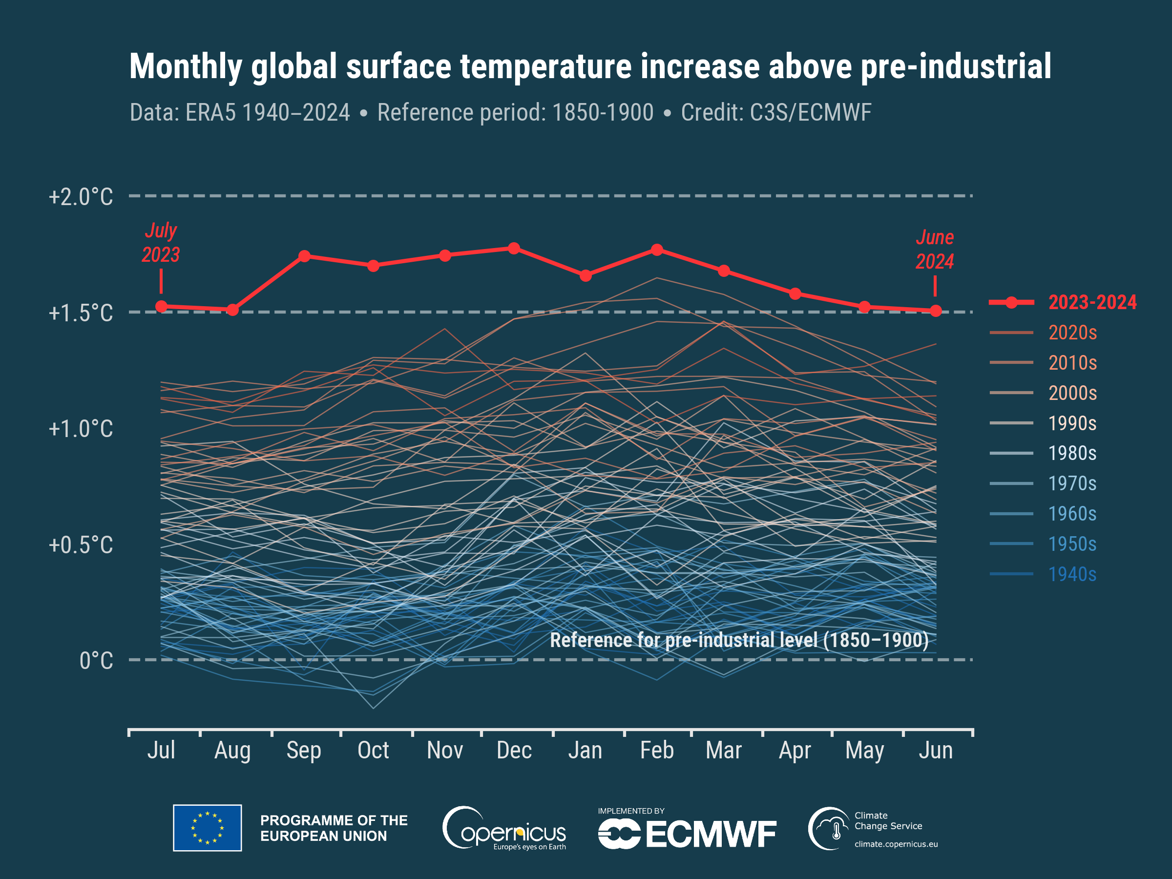
“This is more than a statistical oddity and highlights a large and continuous change in our climate,” commented Carlo Buontempo, director of the Copernicus Climate Change Service.“Even if this specific series of extreme events ends sooner or later, we are destined to see new records broken as the climate continues to warm.This is inevitable unless we stop adding greenhouse gases to the atmosphere and oceans.”
Southeastern Europe and Turkey were the European regions where temperatures were most above average, while they were near or below average in Western Europe, Iceland and northwestern Russia.Outside of Europe, higher-than-average temperatures were recorded in eastern Canada, the western United States, Mexico, Brazil, northern Siberia, the Middle East, northern Africa and western Antarctica.The effect of La Niña moderated temperatures - below average - in the eastern equatorial Pacific, although air temperatures over the ocean remained at an unusually high level in many regions.
The average sea surface temperature for June was 20.85°C, the highest ever recorded for this month.New daily temperature records were set for the seas from March 2023 until the end of June this year, when a slight cooling occurred. According to Buontempo, this is a sign of the expected transition to La Niña:“There is a cooling effect of La Niña [on sea temperatures] and this is widely expected and largely anticipated.But the ocean as a whole remains very warm.”The expected shift to La Niña should also lead to a cooling of surface temperatures, but that doesn't mean the issue is resolved, he added.“If our goal is to stay below 1.5°C, it is not enough to hope for the end of El Niño.”
Ice sheets are near a new tipping point that could mean more sea level rise
A study published on Nature Geoscience examined as with the warming of sea water, warmer water is intruding between the ice sheets and the ground on which they rest.This way, the warmer water melts the cavities in the ice, allowing more water to enter, further expanding the cavities.This process favors the collapse of ice in the ocean and the rise of sea levels.
It is not known how close the turning point is or whether it has already been passed, but according to researchers, increases in temperatures of a few tenths of a degree could now be enough to trigger it.The Pine Island Glacier, which currently contributes the most to sea level rise in Antarctica, is particularly vulnerable, as the base of the glacier slopes inward, meaning that gravity encourages seawater to penetrate.The large Larsen Ice Sheet is also at risk.Sea level rise is the biggest long-term impact of the climate crisis and is set to redraw the world map in the coming centuries.It could bring dozens of major cities, from New York to Shanghai, below sea level and affect billions of people.[Source: Guardian]
According to a new study, protecting just 1.2% of the Earth's surface would be enough to avoid the extinction of the world's most threatened species
One study published in the journal Frontiers in Science he noted that the targeted expansion of protected areas on land would be sufficient to prevent the loss of thousands of mammals, birds, amphibians and plants that are closest to disappearing.From Argentina to Papua New Guinea, the team of researchers identified 16,825 sites that should be conserved as a priority over the next five years to avoid the imminent extinction of animals and plants found nowhere else.Of the identified sites, which the authors called “conservation imperatives,” 38 percent are within a mile (2.5 km) of an existing protected area, indicating they could be easily protected.
In 2022, governments have committed to protecting 30% of the planet.According to the United Nations, 16.6% of the world's land surface and inland waters are protected, and many governments are deciding where to expand conservation areas.However, the study found that governments often fail to safeguard the biodiversity-rich areas that most urgently need protection.The authors estimated that only 7% of newly protected area sites between 2018 and 2023 were home to the most threatened species.[Source: Guardian]
Not just lithium:how a Swedish battery company wants to fuel the ecological transition with salt
About 100 kilometers from Stockholm, Sweden, Northvolt - Europe's only major manufacturer of batteries for electric vehicles - has announced a breakthrough in battery development.The company has produced a one-of-a-kind energy storage battery, replacing the most commonly used critical minerals - such as lithium, cobalt, nickel and graphite - with sodium, a chemical element found in table salt, which is cheaper and much more more abundant, as well as with iron, nitrogen and carbon.“This is a fundamentally new technology,” he said in an interview with Climate Home News Andreas Haas, Northvolt sodium ion program manager.
The timing of the innovation caught the battery industry by surprise.Technology roadmaps in North America and Europe had placed this development closer to 2030 than 2025, according to Daniel Brandell, a materials chemist at Uppsala University in Sweden.Concerns about the social and environmental impacts of mining and refining battery minerals have grown in recent years.
Sodium batteries offer a solution to electric battery supply chain challenges, particularly for Western countries seeking to reduce their dependence on China for clean technologies.According to a Bloomberg analysis, sodium batteries could replace 272,000 tons of lithium demand by 2035, or about 7% of the overall market expected that year.[Source: Climate Home News]
Better refrigeration of food along the supply chain could avoid almost 2 billion tonnes of CO2 per year
According to new research, published in Environmental Research Letters, more consistent refrigeration of food as it travels across the supply chain could reduce greenhouse gas emissions from food loss by nearly 2 billion tons.In fact, every year almost a third of all food produced is wasted, producing greenhouse gases that warm the climate when they rot.
The study found that increased refrigeration during food processing and transportation could more than halve food loss emissions in South and Southeast Asia.Furthermore, according to the research, shortening food supply chains could significantly reduce emissions and prevent food loss around the world.[Source: Carbon Brief]
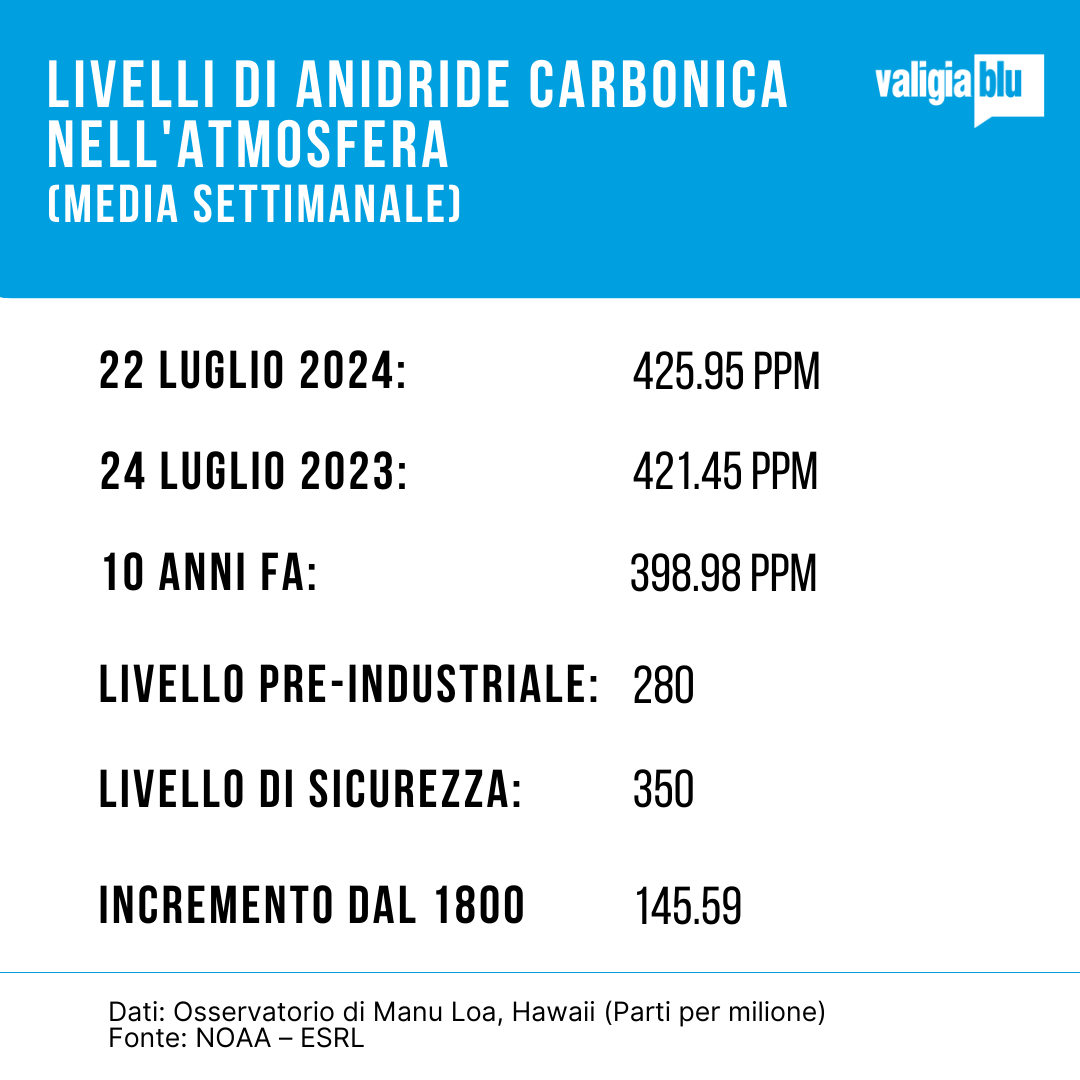
Data on carbon dioxide levels in the atmosphere
Preview image:NBC News video frame via YouTube