El Niño Southern Oscillation
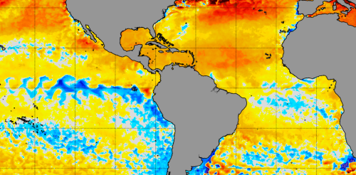
The North Atlantic Ocean has been running a fever for months, with surface temperatures at or near record highs. But cooling along the equator in both the Atlantic and eastern Pacific may finally be starting to bring some relief, particularly for vulnerable coral reef ecosystems. This cooling comes from two climate phenomena with similar names: La Niña, which forms in the tropical Pacific, and the less well-known Atlantic Niña. Both can affect the Atlantic hurricane season. While La Niña tends to bring conditions ideal for Atlantic hurricanes, the less powerful Atlantic Niña has the potential to reduce some of the hurricane risk. Cooling in the tropical Atlantic along the equator is a sign an Atlantic Niña may be forming. NOAA Climate.gov We’re ocean and atmospheric scientists who study this type of climate phenomenon. It’s rare to see both Niñas at the same...
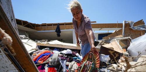
Spring 2024 was unnerving for people across large parts of the U.S. as tornado warnings and sirens sent them scrambling for safety. More than 1,100 tornadoes were reported through May − a preliminary number but nearly twice the 30-year average at that point and behind only 2011, when deadly tornado outbreaks tore across the southeastern U.S. The U.S. experienced several multistate outbreaks in 2024. Tornadoes damaged homes from Texas to Minnesota and east to West Virginia and Georgia. They caused widespread destruction in several towns, including Greenfield, Iowa; Westmoreland, Kansas; and Bartlesville, Oklahoma. Barnsdall, Oklahoma, was hit twice in two months. In May, at least one tornado occurred somewhere in the country almost every day. Greenfield, Iowa, after a powerful EF4 tornado cut through the city on May 21, 2024, amid a deadly tornado outbreak. What causes some years to have so many tornadoes? I’m a meteorologist w...
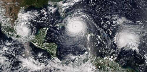
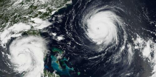
The 2024 Atlantic hurricane season starts on June 1, and forecasters are predicting an exceptionally active season. If the National Hurricane Center’s early forecast, released May 23, is right, the North Atlantic could see 17 to 25 named storms, eight to 13 hurricanes, and four to seven major hurricanes by the end of November. That’s the highest number of named storms in any NOAA preseason forecast. Other forecasts for the season have been just as intense. Colorado State University’s early outlook, released in April, predicted an average of 23 named storms, 11 hurricanes and five major hurricanes. The European Centre for Medium-Range Weather Forecasts anticipates 21 named storms. Colorado State also forecasts a whopping 210 accumulated cyclone energy units for 2024, and NOAA forecasts the second-highest ACE on record. Accumulated cyclone energy is a score for how active a given season is by combining intensity and duration of all storms occurring within a gi...
Weather forecasters talk about wind shear a lot during hurricane season, but what exactly is it? I teach meteorology at Georgia Tech, in a part of the country that pays close attention to the Atlantic hurricane season. Here’s a quick look at one of the key forces that can determine whether a storm will become a destructive hurricane. What is wind shear? Wind shear is defined as the change in wind speed, wind direction, or both, over some distance. You may have heard airplane pilots talk about turbulence and warn passengers that they’re in for a bumpy ride. They’re typically seeing signs of sudden changes in wind speed or wind direction directly ahead, and wind shear can sometimes cause this. With hurricanes, the focus is usually on vertical wind shear, or how wind changes in speed and direction with height. The effects of wind shear when wind speed increases with height (left) or changes direction (right)....
One of the big contributors to the record-breaking global temperatures over the past year – El Niño – is now gone, and its opposite, La Niña, is on the way. Whether that’s a relief or not depends in part on where you live. Above-normal temperatures are still forecast across the U.S. in summer 2024. And if you live along the U.S. Atlantic or Gulf coasts, La Niña can contribute to the worst possible combination of climate conditions for fueling hurricanes. Pedro DiNezio, an atmosphere and ocean scientist at the University of Colorado who studies El Niño and La Niña, explains why and what’s ahead. What is La Niña? La Niña and El Niño are the two extremes of a recurring climate pattern that can affect weather around the world. Forecasters know La Niña has arrived when temperatures in the eastern Pacific Ocean along the equator west of South America cool by at least half a degree Celsius (0.9 Fahrenheit) below no...


