Extreme rainfall
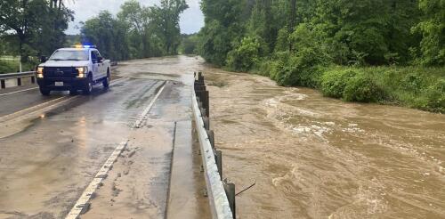
Scenes from the Houston area looked like the aftermath of a hurricane in early May 2024 after a series of powerful storms flooded highways and neighborhoods and sent rivers over their banks north of the city. Hundreds of people had to be rescued from homes, rooftops and cars during storms, according to The Associated Press. Huntsville registered nearly 20 inches of rain from April 29 to May 4. More storm systems over the following weeks blew out windows in Houston high rises and caused more flash flooding on urban streets and already saturated ground in the region. Floods are complex events, and they are about more than just heavy rain. Each community has its own unique geography and climate that can exacerbate flooding. On top of those risks, extreme downpours are becoming more common as global temperatures rise. I work with a center at the University of Michigan that helps communities turn climate knowledge into projects that can reduce the harm of future climate disasters. F...
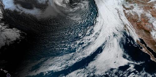
Millions of Californians were under flood alerts as a powerful atmospheric river brought heavy rain to the West Coast in early February 2024. Los Angeles saw one of its wettest days on record with over 4 inches of rain on Feb. 4. Other communities were hit by more than 12 inches of rain and reported widespread flooding. Debris and mudslides shut down sections of highways and roads into Malibu. It was the latest in a series of atmospheric rivers to bring extreme rainfall to the West Coast. While these storms are dreaded for the damage they can cause, they are also essential to the region’s water supply, particularly in California, as Qian Cao, a hydrologist at the University of California, San Diego, explains. What are atmospheric rivers? An atmospheric river is a narrow corridor or filament of concentrated water vapor transported in the atmosphere. It’s like a river in the sky that can be 1,000 miles long. On average, atmospheric rivers have about twice the regul...
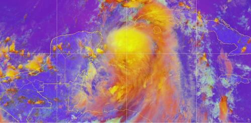
Forecasters expected Hurricane Idalia to intensify into a major hurricane as it headed over exceptionally warm waters in the Gulf of Mexico, on track for landfall in Florida on Wednesday, Aug. 30, 2023. Hurricane warnings were posted along a wide stretch of Florida’s Gulf coast, from near Sarasota to the Panhandle, including Tampa Bay. Hurricane scientist Haiyan Jiang of Florida International University explains how two conflicting forces – record-high ocean heat and wind shear, the latter influenced by El Niño – were determining Idalia’s future, and how they have made the 2023 hurricane season overall difficult to forecast. What role is ocean temperature playing in Idalia’s forecast? Forecasters are watching several factors, but the biggest is the very high sea surface temperature in the Gulf of Mexico. The Gulf is typically warm in late August, and we often see hurricanes this time of year. But this summer, the sea surface temperature has...
Leer en español. Southeast Michigan seemed like the perfect “climate haven.” “My family has owned my home since the ‘60s. … Even when my dad was a kid and lived there, no floods, no floods, no floods, no floods. Until [2021],” one southeast Michigan resident told us. That June, a storm dumped more than 6 inches of rain on the region, overloading stormwater systems and flooding homes. That sense of living through unexpected and unprecedented disasters resonates with more Americans each year, we have found in our research into the past, present and future of risk and resilience. An analysis of federal disaster declarations for weather-related events puts more data behind the fears – the average number of disaster declarations has skyrocketed since 2000 to nearly twice that of the preceding 20-year period. A powerful storm system in 2023 flooded communities across Vermont and left large par...
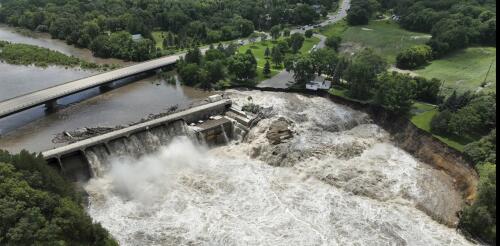
Heavy rainfall generated widespread flooding. in the Upper Midwest in late June 2024, putting at least one aging dam at risk. In southern Minnesota, the Blue Earth River cut a path around the Rapidan Dam in Rapidan Township, about 15 miles south of Mankato, on June 24, putting the structure at imminent risk of failing. Officials warned local residents that if the dam burst, the river could rise by 2 feet, but said that evacuations were not needed. This event comes a year after flooding in Vermont collapsed at least one dam and threatened others. Hiba Baroud, associate professor and associate chair in the department of civil and environmental engineering at Vanderbilt University, explains how flooding stresses dams in a changing climate. How serious is the risk when water flows over or around a dam? These conditions can result in erosion, which subsequently could lead to a dam breach or failure and a sudden, uncontrolled release of impounded water. The risk reflects the combin...


