Hurricanes
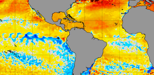
The North Atlantic Ocean has been running a fever for months, with surface temperatures at or near record highs. But cooling along the equator in both the Atlantic and eastern Pacific may finally be starting to bring some relief, particularly for vulnerable coral reef ecosystems. This cooling comes from two climate phenomena with similar names: La Niña, which forms in the tropical Pacific, and the less well-known Atlantic Niña. Both can affect the Atlantic hurricane season. While La Niña tends to bring conditions ideal for Atlantic hurricanes, the less powerful Atlantic Niña has the potential to reduce some of the hurricane risk. Cooling in the tropical Atlantic along the equator is a sign an Atlantic Niña may be forming. NOAA Climate.gov We’re ocean and atmospheric scientists who study this type of climate phenomenon. It’s rare to see both Niñas at the same...
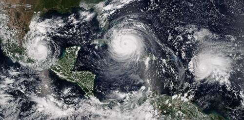
Preparing for Atlantic hurricane season is always a priority in the Caribbean, especially when forecasts project high numbers of storms, as they do for 2024. The region’s most devastating storm in recent years, Hurricane Maria, struck in September 2017 and inflicted unprecedented destruction on Puerto Rico, Dominica, St. Croix and other islands. Maria killed more than 3,000 people and caused about US$96 billion in damage. It devastated Puerto Rico’s electric power system, leaving 1.5 million customers in the dark for up to 328 days – the longest blackout in U.S. history. These outages had cascading impacts on other infrastructure, such as water and communications systems. Today, the Caribbean region is experiencing new climate-related challenges. Prolonged extreme heat and humid days are increasing because of the accelerated warming of ocean waters. In response to these increasingly frequent and extreme weather events, I teamed up with a dozen other resea...
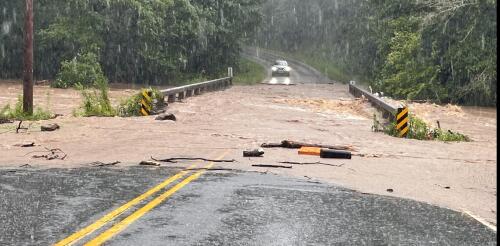
The French Broad River winds through the mountains of western North Carolina, fed by dozens of mountain streams, and crosses the city of Asheville. At over 2,000 feet above sea level and more than 250 miles from the coast, it is an unlikely place to prepare for a hurricane. Yet, the remnants of several hurricanes have swept through this region over the years, sending rivers in the region raging out of their banks. When these storms hit back to back, the devastation can be enormous. In September 2004, for example, remnants of Hurricanes Frances, Ivan and Jeanne all brought excessive rain to western North Carolina in the span of a few weeks, overwhelming the French Broad and other rivers in the Asheville area. Western North Carolina’s history is just one example of the inland risks from tropical cyclones. A U.S. map of hurricane storm tracks since 1851 shows that the storms and their remnants often travel far inland. Yellows to reds...
The 2024 Atlantic hurricane season starts on June 1, and forecasters are predicting an exceptionally active season. If the National Hurricane Center’s early forecast, released May 23, is right, the North Atlantic could see 17 to 25 named storms, eight to 13 hurricanes, and four to seven major hurricanes by the end of November. That’s the highest number of named storms in any NOAA preseason forecast. Other forecasts for the season have been just as intense. Colorado State University’s early outlook, released in April, predicted an average of 23 named storms, 11 hurricanes and five major hurricanes. The European Centre for Medium-Range Weather Forecasts anticipates 21 named storms. Colorado State also forecasts a whopping 210 accumulated cyclone energy units for 2024, and NOAA forecasts the second-highest ACE on record. Accumulated cyclone energy is a score for how active a given season is by combining intensity and duration of all storms occurring within a gi...
Weather forecasters talk about wind shear a lot during hurricane season, but what exactly is it? I teach meteorology at Georgia Tech, in a part of the country that pays close attention to the Atlantic hurricane season. Here’s a quick look at one of the key forces that can determine whether a storm will become a destructive hurricane. What is wind shear? Wind shear is defined as the change in wind speed, wind direction, or both, over some distance. You may have heard airplane pilots talk about turbulence and warn passengers that they’re in for a bumpy ride. They’re typically seeing signs of sudden changes in wind speed or wind direction directly ahead, and wind shear can sometimes cause this. With hurricanes, the focus is usually on vertical wind shear, or how wind changes in speed and direction with height. The effects of wind shear when wind speed increases with height (left) or changes direction (right)....
