Hurricanes
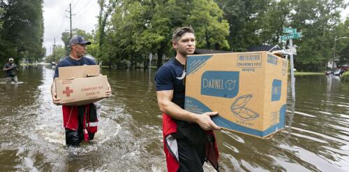
Tropical Storm Debby was moving so slowly, Olympians could have outrun it as it moved across the Southeast in early August 2024. That gave its rainfall time to deluge cities and farms over large parts of Florida, Georgia and the Carolinas. More than a foot of rain had fallen in some areas by early Aug. 7, 2024, with more days of rain forecast there and into the Northeast. Mathew Barlow, a climate scientist at UMass Lowell, explains how storms like Debby pick up so much moisture, what can cause them to slow or stall, and what climate change has to do with it. What causes hurricanes to stall? Hurricanes are steered by the weather systems they interact with, including other storms moving across the U.S. and the Bermuda High over the Atlantic Ocean. A hurricane may be moving slowly because there are no weather systems close enough to pull the hurricane along, or there might be a high-pressure system to the north of the hurricane that blocks its forward movement. In this case,...
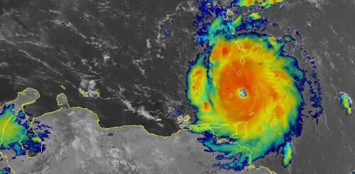
Hurricane Beryl was the latest Atlantic storm to rapidly intensify, growing quickly from a tropical storm into the strongest June hurricane on record in the Atlantic. It hit the Grenadine Islands with 150 mph winds and a destructive storm surge on July 1, 2024, then continued to intensify into the basin’s earliest Category 5 storm on record. Beryl was still a powerful Category 4 hurricane on July 3 when its eyewall brushed the coast of Jamaica and headed toward the Cayman Islands. A large part of Mexico’s Yucatan Peninsula was under a hurricane warning. The damage Beryl caused, particularly on Carriacou and Petite Martinique, was extensive, Grenada Prime Minister Dickon Mitchell told a news briefing. “In half an hour, Carriacou was flattened.” Beryl’s strength and rapid intensification were unusual for a storm so early in the season. This year, that is especially alarming as forecasters expect an exceptionally active Atlantic hurricane season....
Tropical Storm Debby was moving so slowly, Olympians could have outrun it as it moved across the Southeast in early August 2024. That gave its rainfall time to deluge cities and farms over large parts of Florida, Georgia and the Carolinas. More than a foot of rain had fallen in some areas by early Aug. 7, 2024, with more days of rain forecast there and into the Northeast. Mathew Barlow, a climate scientist at UMass Lowell, explains how storms like Debby pick up so much moisture, what can cause them to slow or stall, and what climate change has to do with it. What causes hurricanes to stall? Hurricanes are steered by the weather systems they interact with, including other storms moving across the U.S. and the Bermuda High over the Atlantic Ocean. A hurricane may be moving slowly because there are no weather systems close enough to pull the hurricane along, or there might be a high-pressure system to the north of the hurricane that blocks its forward movement. In this case,...
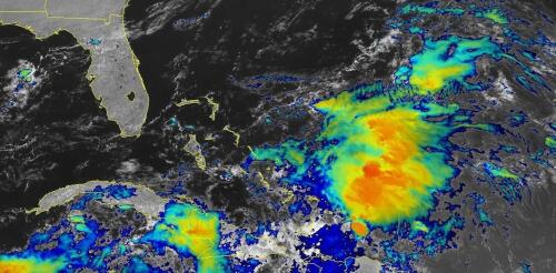
When tropical meteorologists peer at satellite images, they often catch sight of subtle cloud formations hinting at something more ominous brewing. The first signs of a potential hurricane can be detected days before a storm gains its fierce momentum. Wispy cirrus clouds radiating outward, the appearance of curved banding low-level clouds and a drop in atmospheric pressure are all clues. These early clues are crucial for predicting the onset of what might develop into a catastrophic hurricane. I am a meteorology professor at Penn State, and my research group uses satellites and computer models to improve forecasting of tropical weather systems. With an especially fierce Atlantic storm season forecast for 2024, being able to detect these initial signals and provide early warnings is more important than ever. Here’s what forecasters look for. Hurricane Harvey entered the Gulf of Mexico as a tropical wave before reorganizing into a tropical storm a...
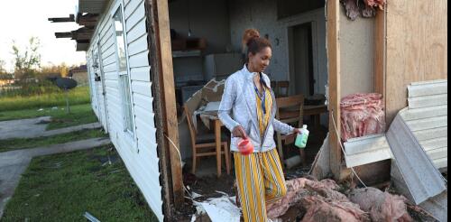
Most Americans will remember 2020 as the year when the pandemic changed everything. But for Lake Charles, Louisiana, and its neighbors along the Gulf Coast, it was also the year of record-setting disasters, when “once-in-a-lifetime” storms hit in such rapid succession that their impacts blurred together. A recent National Academies consensus study I worked on looked into the compounding disasters that the region faced – both physical and socioeconomic – as storm after storm arrived during the pandemic with little time for recovery. It concludes that Lake Charles’ experiences could be a harbinger of what’s to come in a warming world unless the nation fundamentally rethinks its disaster preparedness, response and recovery strategies. Lake Charles’ compounding disasters Hurricane Laura made landfall near Lake Charles on Aug. 27, 2020, as a powerful Category 4 storm, with wind speeds exceeding those that local building codes were designed...


