
 italiano
 english
 français
 española
 中国
中国 日本の
日本の العربية
 Deutsch
 한국어
한국어 Português
 Russian
Hurricane
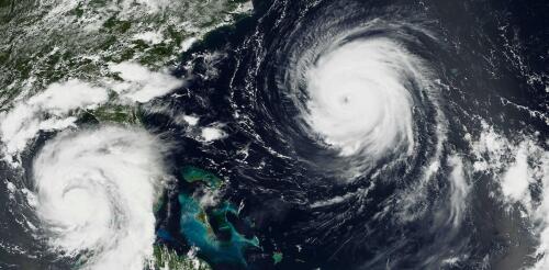
Hurricane Beryl was the latest Atlantic storm to rapidly intensify, growing quickly from a tropical storm into the strongest June hurricane on record in the Atlantic. It hit the Grenadine Islands with 150 mph winds and a destructive storm surge on July 1, 2024, then continued to intensify into the basin’s earliest Category 5 storm on record. Beryl was still a powerful Category 4 hurricane on July 3 when its eyewall brushed the coast of Jamaica and headed toward the Cayman Islands. A large part of Mexico’s Yucatan Peninsula was under a hurricane warning. The damage Beryl caused, particularly on Carriacou and Petite Martinique, was extensive, Grenada Prime Minister Dickon Mitchell told a news briefing. “In half an hour, Carriacou was flattened.” Beryl’s strength and rapid intensification were unusual for a storm so early in the season. This year, that is especially alarming as forecasters expect an exceptionally active Atlantic hurricane season....
Weather forecasters talk about wind shear a lot during hurricane season, but what exactly is it? I teach meteorology at Georgia Tech, in a part of the country that pays close attention to the Atlantic hurricane season. Here’s a quick look at one of the key forces that can determine whether a storm will become a destructive hurricane. What is wind shear? Wind shear is defined as the change in wind speed, wind direction, or both, over some distance. You may have heard airplane pilots talk about turbulence and warn passengers that they’re in for a bumpy ride. They’re typically seeing signs of sudden changes in wind speed or wind direction directly ahead, and wind shear can sometimes cause this. With hurricanes, the focus is usually on vertical wind shear, or how wind changes in speed and direction with height. The effects of wind shear when wind speed increases with height (left) or changes direction (right)....
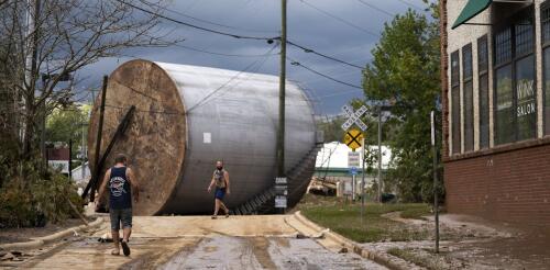
Hundreds of industrial facilities with toxic pollutants were in Hurricane Helene’s path as the powerful storm flooded communities across the Southeast in late September 2024. Near the coast and into Georgia, Helene swept over paper mills, fertilizer factories and oil and gas storage facilities. Paper mills are among the most polluting industries on the planet – some with thousands of pounds of lead on-site from prior production practices. Florida officials reported that a retired nuclear power plant just south of Cedar Key experienced a storm surge of as much as 12 feet that inundated buildings and an industrial wastewater pond. Spent nuclear fuel stored at the site, which also flooded during Hurricane Idalia in 2023, was believed to be secure, Bloomberg reported. Further inland, the storm dumped more than a foot of rain on industrial sites in the Carolinas and Tennessee, some near waterways that quickly flooded with runoff from the mountains....
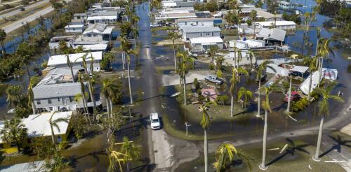
Warm water in the Atlantic Ocean and Gulf of Mexico can fuel powerful hurricanes, but how destructive a storm becomes isn’t just about the climate and weather – it also depends on the people and property in harm’s way. In many coastal cities, fast population growth has left more people living in areas at high risk of flooding. I am a geographer who studies the human dimensions of climate change and natural disasters. My research and mapping with colleagues shows that socially vulnerable communities – those least able to prepare for disasters or recover afterward – tend to be concentrated in areas that are more susceptible to flooding, particularly on the Gulf Coast. Larger, vulnerable populations Nearly 40% of the U.S. population lives in a coastal county today. Many of these areas are increasingly exposed to disasters, including hurricanes and high tide flooding that has been worsened by sea level rise. The Gulf of Mexico region, in particular,...
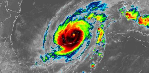
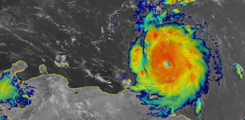
Hurricane Milton became one of the most rapidly intensifying storms on record as it went from barely hurricane strength to a dangerous Category 5 storm in less than a day on a path across the Gulf of Mexico toward Florida. With sustained winds that reached 180 mph on Oct. 7, 2024, and very low pressure, it also became one of the strongest Atlantic storms. Milton’s winds dipped to Category 4 strength early on Oct. 8, but forecasters warned that it would still be an extremely dangerous hurricane at landfall. Less than two weeks after Hurricane Helene’s devastating impact, this kind of storm was the last thing Florida wanted to see. Hurricane Milton was expected to make landfall as a major hurricane on Oct. 9 and had already prompted widespread evacuations. Hurricane Milton’s projected storm track, as of midday Oct. 7, 2024, as it grew into a major hurricane (M). Storm tracks are projections, and Milton’s path co...