Weather satellites
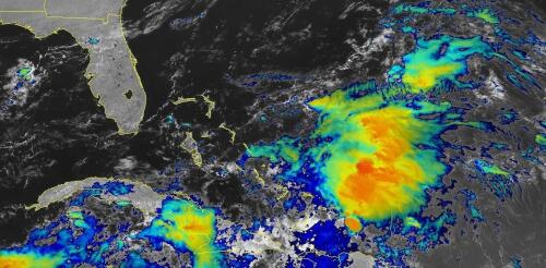
When tropical meteorologists peer at satellite images, they often catch sight of subtle cloud formations hinting at something more ominous brewing. The first signs of a potential hurricane can be detected days before a storm gains its fierce momentum. Wispy cirrus clouds radiating outward, the appearance of curved banding low-level clouds and a drop in atmospheric pressure are all clues. These early clues are crucial for predicting the onset of what might develop into a catastrophic hurricane. I am a meteorology professor at Penn State, and my research group uses satellites and computer models to improve forecasting of tropical weather systems. With an especially fierce Atlantic storm season forecast for 2024, being able to detect these initial signals and provide early warnings is more important than ever. Here’s what forecasters look for. Hurricane Harvey entered the Gulf of Mexico as a tropical wave before reorganizing into a tropical storm a...
If you want to track changes in the Amazon rainforest, see the full expanse of a hurricane or figure out where people need help after a disaster, it’s much easier to do with the view from a satellite orbiting a few hundred miles above Earth. Traditionally, access to satellite data has been limited to researchers and professionals with expertise in remote sensing and image processing. However, the increasing availability of open-access data from government satellites such as Landsat and Sentinel, and free cloud-computing resources such as Amazon Web Services, Google Earth Engine and Microsoft Planetary Computer, have made it possible for just about anyone to gain insight into environmental changes underway. I work with geospatial big data as a professor. Here’s a quick tour of where you can find satellite images, plus some free, fairly simple tools that anyone can use to create time-lapse animations from satellite images. For example, state and urban planners –...

