Atmosphere
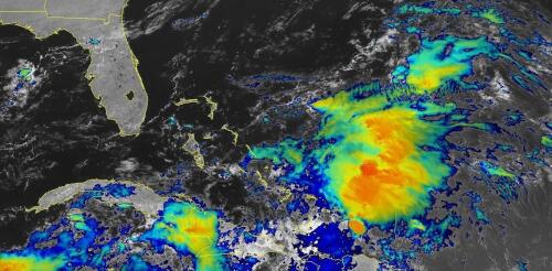
When tropical meteorologists peer at satellite images, they often catch sight of subtle cloud formations hinting at something more ominous brewing. The first signs of a potential hurricane can be detected days before a storm gains its fierce momentum. Wispy cirrus clouds radiating outward, the appearance of curved banding low-level clouds and a drop in atmospheric pressure are all clues. These early clues are crucial for predicting the onset of what might develop into a catastrophic hurricane. I am a meteorology professor at Penn State, and my research group uses satellites and computer models to improve forecasting of tropical weather systems. With an especially fierce Atlantic storm season forecast for 2024, being able to detect these initial signals and provide early warnings is more important than ever. Here’s what forecasters look for. Hurricane Harvey entered the Gulf of Mexico as a tropical wave before reorganizing into a tropical storm a...
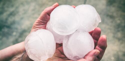
Hail the size of grapefruit shattered car windows in Johnson City, Texas. In June, 2024, a storm chaser found a hailstone almost as big as a pineapple. Even larger hailstones have been documented in South Dakota, Kansas and Nebraska. Hail has damaged airplanes and even crashed through the roofs of houses. How do hailstones get so large, and are hailstorms getting worse? As an atmospheric scientist, I study and teach about extreme weather and its risks. Here’s how hail forms, how hailstorms may be changing, and some tips for staying safe. How does hail get so big? Hail begins as tiny crystals of ice that are swept into a thunderstorm’s updraft. As these ice embryos collide with supercooled water – liquid water that has a temperature below freezing – the water freezes around each embryo, causing the embryo to grow. A hailstone cut in half, which reveals layers of clear and cloudy ice formed as the hailstone journe...
Dozens of tornadoes hit the central U.S. April 26-28, 2024, tearing through suburbs and small towns and damaging hundreds of homes from Oklahoma to Nebraska and Iowa. Spring is tornado season in the U.S., but the tornadoes in Nebraska and Iowa were quite a bit farther north and east of what would be typical for tornadoes in late April, when tornado activity is more common in Oklahoma and Texas. The outbreak did fit another pattern for severe weather events, however, that occur as the atmosphere transitions out of El Niño. And this is exactly what was happening in late April. I study tornadoes and the conditions under which they form. Here’s how these storm systems develop and what El Niño has to do with it. Preliminary reports of tornadoes and hail during severe storms on April 26, 2024, collected by the National Oceanic and Atmospheric Administration’s Storm Prediction Center. NOAA...
Meteorologists have been talking for weeks about a snowy season ahead in the southern Rockies and the Sierra Nevada. They anticipate more storms in the U.S. South and Northeast, and warmer, drier conditions across the already dry Pacific Northwest and the upper Midwest. One phrase comes up repeatedly with these projections: a strong El Niño is coming. It sounds ominous. But what does that actually mean? We asked Aaron Levine, an atmospheric scientist at the University of Washington whose research focuses on El Niño. NOAA explains in animations how El Niño forms. What is a strong El Niño? During a normal year, the warmest sea surface temperatures are in the western Pacific and the Indian Ocean, in what’s known as the Indo-Western Pacific warm pool. But every few years, the trade winds that blow from east to west weaken, allowing that warm water to slosh eastward and pile up along the equator. The warm water causes...
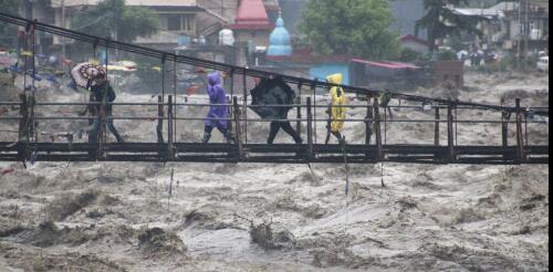
Torrential downpours sent muddy water racing through streets in Libya, Greece and Spain and flooded parts of Hong Kong and New York City in September 2023. Thousands of people died in the city of Derna, Libya. Zagora, Greece, saw a record 30 inches of rain, the equivalent of a year and a half of rain falling in 24 hours. A few weeks earlier, monsoon rains triggered deadly landslides and flooding in the Himalayas that killed dozens of people in India. After severe flooding on almost every continent this year, including mudslides and flooding in California in early 2023 and devastating floods in Vermont and New York in July, it can seem like extreme rainfall is becoming more common. So, what role does global warming play in this? And importantly, what can we do to adapt to this new reality? A powerful storm system in 2023 flooded communities across Vermont and left large parts of the capital, Montpelier, underwater. John Tul...


