Atmospheric science
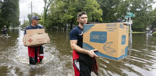
Tropical Storm Debby was moving so slowly, Olympians could have outrun it as it moved across the Southeast in early August 2024. That gave its rainfall time to deluge cities and farms over large parts of Florida, Georgia and the Carolinas. More than a foot of rain had fallen in some areas by early Aug. 7, 2024, with more days of rain forecast there and into the Northeast. Mathew Barlow, a climate scientist at UMass Lowell, explains how storms like Debby pick up so much moisture, what can cause them to slow or stall, and what climate change has to do with it. What causes hurricanes to stall? Hurricanes are steered by the weather systems they interact with, including other storms moving across the U.S. and the Bermuda High over the Atlantic Ocean. A hurricane may be moving slowly because there are no weather systems close enough to pull the hurricane along, or there might be a high-pressure system to the north of the hurricane that blocks its forward movement. In this case,...
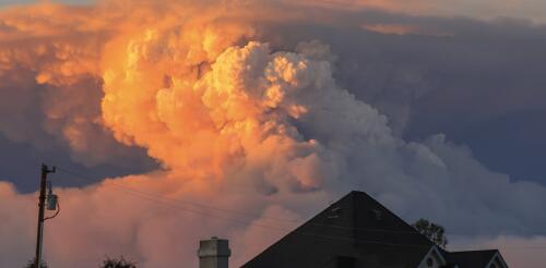
Wildfire blowups, fire whirls, towering thunderstorms: When fires get large and hot enough, they can actually create their own weather. In these extreme fire situations, firefighters’ ordinary methods to directly control the fire don’t work, and wildfires burn out of control. Firefighters have seen many of these risks in the enormous Park Fire burning near Chico, California, and other wildfires in summer 2024. But how can a fire create weather? Satellite images show how the Park Fire near Chico, Calif., created intense pyrocumulonimbus plumes, visible in white, in July 2024. CSU/CIRA and NOAA I’m an atmospheric scientist who uses data collected by satellites in weather prediction models to better anticipate extreme fire weather phenomena. Satellite data shows fire-produced thunderstorms are much more common than anyone realized just a few years ago. Here’s what’s happ...
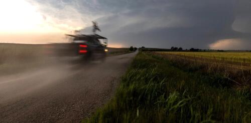
Storm-chasing for science can be exciting and stressful – we know, because we do it. It has also been essential for developing today’s understanding of how tornadoes form and how they behave. In 1996, the movie “Twister” with Helen Hunt brought storm-chasing scientists into the public imagination and inspired a generation of atmospheric scientists. With the new “Twisters” movie hitting theaters, we’ve been getting questions about storm-chasing – or storm intercepts, as we call them. Here are some answers about what scientists who do this kind of fieldwork are really up to when they race off after storms. Scientists with the National Severe Storms Lab ‘intercepted’ this tornado to collect data using mobile radar and other instruments on May 24, 2024. National Severe Storms Lab What does a day of storm-chasing really look like? The morning...
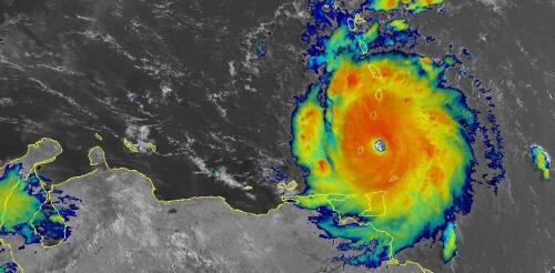
Hurricane Beryl was the latest Atlantic storm to rapidly intensify, growing quickly from a tropical storm into the strongest June hurricane on record in the Atlantic. It hit the Grenadine Islands with 150 mph winds and a destructive storm surge on July 1, 2024, then continued to intensify into the basin’s earliest Category 5 storm on record. Beryl was still a powerful Category 4 hurricane on July 3 when its eyewall brushed the coast of Jamaica and headed toward the Cayman Islands. A large part of Mexico’s Yucatan Peninsula was under a hurricane warning. The damage Beryl caused, particularly on Carriacou and Petite Martinique, was extensive, Grenada Prime Minister Dickon Mitchell told a news briefing. “In half an hour, Carriacou was flattened.” Beryl’s strength and rapid intensification were unusual for a storm so early in the season. This year, that is especially alarming as forecasters expect an exceptionally active Atlantic hurricane season....
Tropical Storm Debby was moving so slowly, Olympians could have outrun it as it moved across the Southeast in early August 2024. That gave its rainfall time to deluge cities and farms over large parts of Florida, Georgia and the Carolinas. More than a foot of rain had fallen in some areas by early Aug. 7, 2024, with more days of rain forecast there and into the Northeast. Mathew Barlow, a climate scientist at UMass Lowell, explains how storms like Debby pick up so much moisture, what can cause them to slow or stall, and what climate change has to do with it. What causes hurricanes to stall? Hurricanes are steered by the weather systems they interact with, including other storms moving across the U.S. and the Bermuda High over the Atlantic Ocean. A hurricane may be moving slowly because there are no weather systems close enough to pull the hurricane along, or there might be a high-pressure system to the north of the hurricane that blocks its forward movement. In this case,...


