
 italiano
 english
 français
 española
 中国
中国 日本の
日本の العربية
 Deutsch
 한국어
한국어 Português
 Russian
New York City

The Northeast corridor is America’s busiest rail line. Each day, its trains deliver 800,000 passengers to Boston, New York, Philadelphia, Washington and points in between. The Northeast corridor is also a name for the place those trains serve: the coastal plain stretching from Virginia to Massachusetts, where over 17% of the country’s population lives on less than 2% of its land. Northeasterners ride the corridor and live there too. Like “Rust Belt,” “Deep South,” “Silicon Valley” and “Appalachia,” “Corridor” has become shorthand for what many people think of as the Northeast’s defining features: its brisk pace of life, high median incomes and liberal politics. In 1961, Republican Sen. Barry Goldwater of Arizona wished someone had “sawed off the Eastern Seaboard and let it float out to sea.” In 2016, conservative F.H. Buckley disparaged “lawyers, academics, trust-fund babies and high...
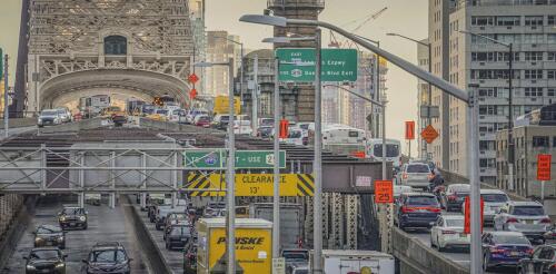
New York City is poised to launch the first congestion pricing plan to reduce traffic in a major U.S. metropolitan area. Like many journeys in the Big Apple, this one has been punctuated by delays. Once the system starts up, however, it’s expected to significantly reduce gridlock in Manhattan and generate billions of dollars to improve public transit citywide. The basic idea is simple. To enter the Congestion Relief Zone, which covers Manhattan south of 60th Street, large trucks will pay $36, small trucks $24, passenger vehicles $15 and motorcycles $7.50. Ride-share vehicles and taxis will pay $2.50 and $1.25, respectively. Peak hours run from 5 a.m. to 9 p.m. on weekdays and 9 a.m. to 9 p.m. on weekends; overnight tolls are discounted by 75%. Evidence from cities around the world shows that charging motorists fees for driving into city centers during busy periods is a rarity in urban public policy: a measure that works and is cost-effective. Congestion pricing has succeed...
Sea level rise has already put coastal cities on notice thanks to increasing storm surges and even sunny day flooding at high tide. These challenges will continue to grow because global projections point to a mean sea level rise of at least one foot above year-2000 levels by the end of this century. However, many cities are facing another factor making them even more vulnerable to rising waters: land subsidence. The three of us – Pei-Chin Wu, Meng (Matt) Wei and Steven D'Hondt – are scientists at the University of Rhode Island Graduate School of Oceanography working with the U.S. Geological Survey to research challenges facing waterfront cities. Our findings indicate that land is sinking faster than sea levels are rising in many coastal cities throughout the world. By using radar images of the Earth’s surface collected from orbiting satellites, we measured subsidence rates in 99 coastal cities worldwide. These rates are highly variable within cities and from...